Israel is expanding the war in the Gaza Strip into Hamas’s last stronghold of Rafah, defying the U.S. and threatening to exacerbate the humanitarian crisis in a city where more than a million Palestinians are sheltering.
There has been steady progress from northern Gaza down the strip, leaving Rafah as the remaining city where the Israeli military hasn’t operated extensively with ground troops.
Israel’s Oct. 27 ground invasion forced more than a million people in the area of the strip’s biggest population hub, Gaza City, to flee south. Those displaced people poured into Rafah as Israel took over Gaza’s central belt and the city of Khan Younis. Rafah, according to the Israeli military, is home to Hamas’s last four battalions.
On Tuesday, Israeli soldiers seized the Rafah crossing, the strip’s border gateway to Egypt. Israel said controlling the crossing is essential to shutting down tunnels used by militants to smuggle weapons and other materials into Gaza.
The Israeli military made its first incursion into Rafah on Tuesday after weeks of threats, taking the Gaza side of the border crossing with Egypt.
Israel hasn’t said whether its move signals the start of a full-scale assault on the city, or if the military could dial back the operation if there is a breakthrough in cease-fire talks. The U.S. opposes a major military operation in Rafah, citing humanitarian concerns and fear of civilian casualties.
About one million people are now sheltering in Rafah and its environs, almost quadrupling the area’s prewar population. Across Gaza, about 1.7 million people, or around 75% of the population, are internally displaced, according to the United Nations agency responsible for Palestinian refugees.
The Rafah governorate is around 25 square miles, about half the size of San Francisco. Population density has grown from 4,360 individuals per square kilometer before Oct. 7, to about 17,500 individuals per square kilometer now, according to the agency.
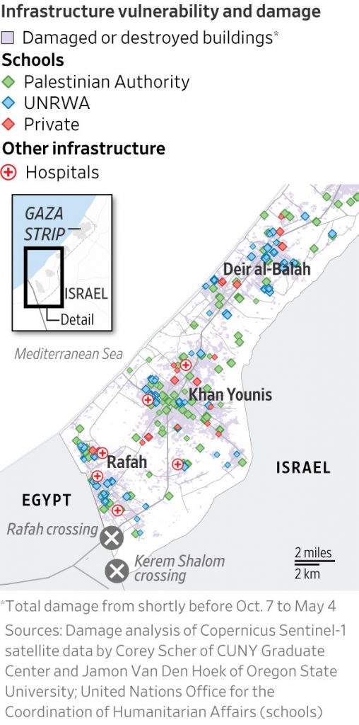
Israeli aerial bombardment and demolitions have devastated infrastructure across Gaza, with some researchers estimating that more than half of the buildings in Khan Younis and about a third of the structures in Rafah are damaged or destroyed. Most of Gaza’s medical infrastructure is shut down, with only a handful of hospitals still operating.
Israel has said it is targeting militant facilities that are embedded in Gaza’s infrastructure, reflecting Hamas’s strategy of entrenching itself in the civilian landscape. Hamas has hundreds of miles of underground tunnels curling throughout the strip, many of which have shafts that open into the ground floor of buildings such as schools and mosques. The Israeli military regularly breaches walls to create entrances into buildings, to avoid extensive booby traps.
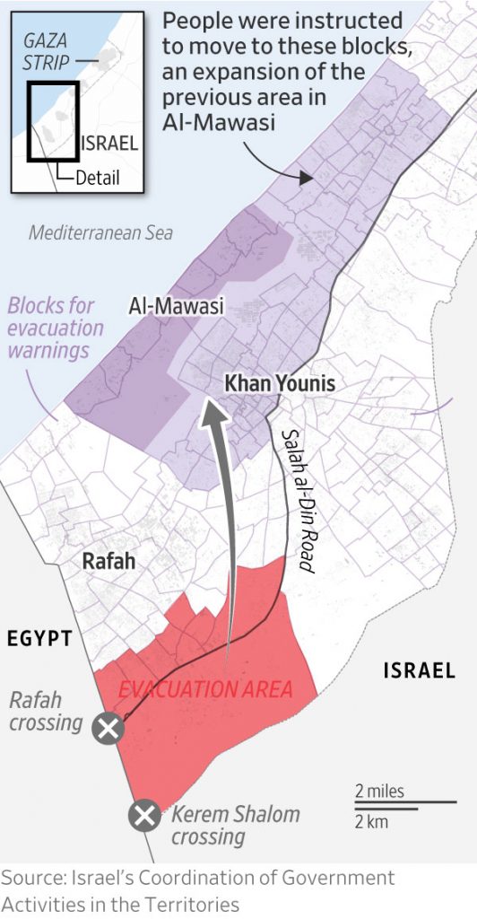
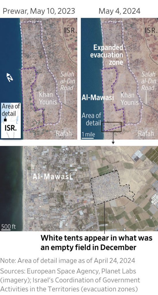
On Monday, the Israeli military instructed civilians to move from the shaded red area in eastern Rafah in the map below toward the shaded purple zones, in Al-Mawasi and in Khan Younis. Israel had designated the dark purple zone as an evacuation area, and the military recently expanded it to include the areas marked light purple, as preparations for a Rafah ground operation got under way.
Palestinians seeking shelter have flowed into Al-Mawasi in recent weeks, crowding into an area that had minimal facilities before the war. The Israeli military has said it would stock evacuation zones with food, water, shelter and medical supplies. In April, Israel’s Defense Ministry made preparations to purchase about 40,000 tents to be set up in these humanitarian zones, an Israeli official said.
Write to Emma Brown at Emma.Brown@wsj.com , Carl Churchill at carl.churchill@wsj.com and Camille Bressange at camille.bressange@wsj.com


